Vlora - changing names already point to the changing history
- Written by Portal Editor
On the way to the south of Albania, we reached Tirana and the port city of Durres and next to it Vlora, another important coastal city with the seat of various authorities of the Qark or better using the term district same named which includes the surrounding area and the Albanian Riviera as well as the regions of Saranda and Delvina.
Vlora is also an important ancient port city, located on the road from Otranto, the narrowest point on the Adriatic and thus the shortest route to Italy. The bay of Vlora and the beaches near the city are popular destinations for tourists since years. At the exit, about 15 kilometers west of the city, lies Sazan, the only large island of Albania. It is just about 90 kilometers to Italy from here.
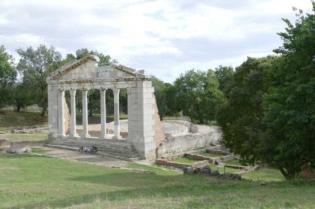
Ancient walls in the cityscape of Vlora
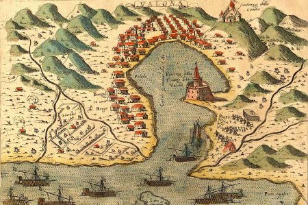
Thanks to its strategic position at the entrance to the Adriatic Sea, the bay of Vlora, which forms a natural harbor, was a commercial center sought for by many peoples. The name of the city in the different languages already indicates the changeable history of the city: thus Vlora is called Avlóna in Greek language, in Italian it is called Valona and in Turkish Avlonya. For the development of the city in antiquity another sequence followed: a change of location from Treport to Vlora during the 1st century BC. And another important large migration happened in the 6th century AD

Roman sources from the 2nd century AD mentioned a stop on the trade route along the coast between Dyrrhachium and Buthrotum. Next to the Muradie mosque in the old part of the city fortification, dating from the 4th century AD, other evidences have been excavated since 1988, the Roman Aulon is believed to be the site of today's city. In the 5th century, Aulon became a bishopric within these fortified walls. With Emperor Justinian (527-565), the walls were reinforced. Another immigration period took place from the abandoned Apollonia in the 6th century, where next to Durres was the second starting point of the Via Egnatia.
Ottoman rule in the Middle Ages
In 1537, under the reign of Suleiman I, the city was secured by fortress walls in the form of an octagon with 90 meters of edge length, partly with building material from ancient Daulia. Inside was also a mighty round tower; all fortifications were demolished until 1906 and the material was used for the construction of the main road to the port.
Evliya Çelebi reported in detailed manor about Vlora and the surrounding area in November 1670. Within the fortified city walls there were about 300 mud houses and a marketplace. Outside the city fortress, around 1,000 other stone houses - some of them multi-storeyed - spread out over a green plain. There were many different fruits and plants extensively grown there.
In September 1690 Vlora got under control of the Republic of Venice and 1691 again back to the Ottomans. Under Ottoman rule Vlora - now Turkish Avlona - developed into the most important port city in the area of Albania and profited above all from the trade with Ragusa.
In 1810 Tepedelenli Ali Pasha was able to annex the city for a short time to his dominion, until the Ottoman Sultan recaptured Vlora when Ali Pasha fell victim to an assassination attempt in 1822.
Vlora - modern times and development
The city center of Vlora today is located about one kilometer from the shores of the sea. Downtown and the harbor area Skela are grown together since decades. Skela also has important facilities such as the university and the football stadium. The settlement area of the city also extends further south along the shore of the bay to Ujë i ftohtë. In the west of the city are larger industrial and port facilities have been built.
The urban area is nestled between the sea, the lagoon of Narta and hills, the foothills of the coastal mountains. The Shushica flows just a few kilometers east past Vlora and flows into the Vjosa next to the village of Armen. From Vlora to the north stretches the about 150 kilometers long coastal plain of Albania. In the south on the other side of the bay the peninsula Karaburun rises at over 800 meters above sea level. The hills in the east of the city are foothills of the Ceraunian Mountains, which reaches heights of more than 2000 meters south of Vlora.
Titelbild: Simon Pinargenti
Please read as well:
From Camping Rino in Kalista to Elbasan
The Ottoman bridge Ura e Mesit next to Shkodra
