Lycian Way - Hiking from Antalya to Fethiye
- Written by Portal Editor

Readers have written to us several times and asked for information about the most famous of the Turkish hiking trails, the Lycian Trail.
We are happy to comply with this request and would like to say a few words about this wonderful hiking trail here.
Hiking trail along the Lycian coast
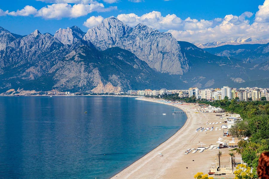 Just behind Antalya, this hiking trail begins along the Lycian coast and through the rugged Taurus Mountains, which is so popular with many experts, and then ends near Fethiye / Ölüdeniz after a total of 509 kilometres, which loops around almost all of Lycia's important sights. Walking this trail in one go requires very intensive training (experts say it takes up to half a year) and about 5 weeks of time.
For most visitors, this is almost impossible to organize and so this hiking trail is often broken down into sections. One of the most popular sections of the Lycian Trail is the section between Kekova and Patara.
 Many publications in the media, including the English “Sunday Times”, speak of the most beautiful hiking trail in the world. If you decide to walk it in whole or in part, always keep an eye out for yellow signposts with the inscription Likya Yolu. No matter where you join the hiking trail from, it is marked white and red throughout. If you see a red cross, you have left the Lycian Trail.
A large proportion of hikers prefer to spend the night in sleeping bags somewhere along the trail, but more and more small guesthouses are now opening that are geared towards hikers and provide rooms for overnight stays.
Best time to hike
The Lycian Trail can be hiked all year round. On the stages west of Finike and near Kemer at altitudes over 1000 m, you should expect plenty of snow from January to March. On the battered summit of the 2365 m high Tahtali, there may still be larger snowfields until May.
From March to the beginning of July and from mid-September to December it is ideal for hiking or trekking on the Lycian Way.
Lycian Coast Tours
 Tour 1: To the Lycian Coast lookout
After breakfast we set off for the starting point of our immigration tour in the former fishing village of Çamyuva.
We hike first surrounded by a dense forest until we reach a slightly ascending path that leads us, accompanied by pine trees, to the small mountain Kapei Patika (305 m). At the summit we reach the Kemer fire station, where there are wonderful views of the Lycian coastline from Antalya to Kemer. Then a shady descent takes us to the port of Kemer, where we will be pampered with local specialties and Turkish hospitality. Ascent: approx. 350 meters in altitude. Descent: approx. 350 meters in altitude, length: approx. 8 km. Reine (walking time: approx. 2-3 hours).
Tour 2: The eternal fires of Lycian Olympos
 Starting from shady orange groves, the path leads us along the Ulupinar Cayi torrent through pine forests to a water ford, which is crossed with the help of a fallen tree. From there up through a romantic pine forest to the "jelly-snorting, three-shaped monster", the Chimera. The sailors of antiquity already saw this unique natural spectacle of an everlasting, natural flame as the home of Hephoistos, the god of fire.
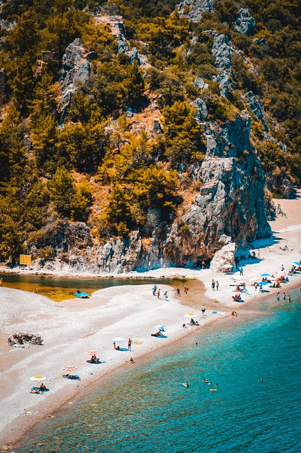
After that, a short climb leads to a breathtaking viewpoint of the Beydaglari, with a view of the destination of our hike, the magnificent bay of Olympos. This ancient site is located in a magnificent natural landscape with one of the most beautiful beaches on the Lycian peninsula. Swimming possible. Ascent: approx. 350 meters in altitude. Descent: a. 350 meters in altitude. Distance: approx. 12 km. Reine (walking time: approx. 3-4 hours).
Tour 3: The vision of Laicos of Rhodes
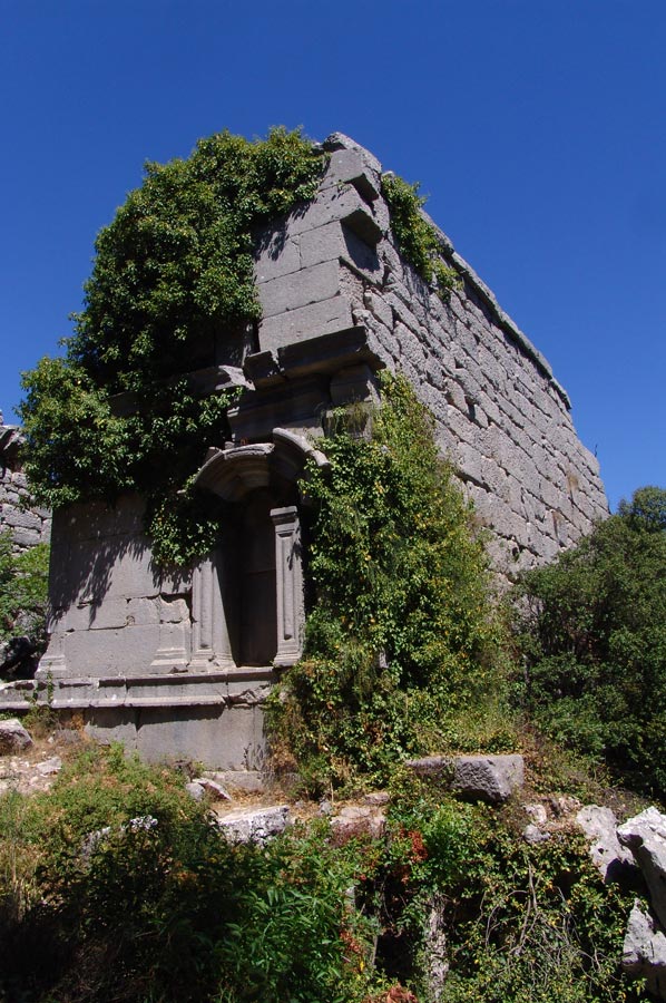
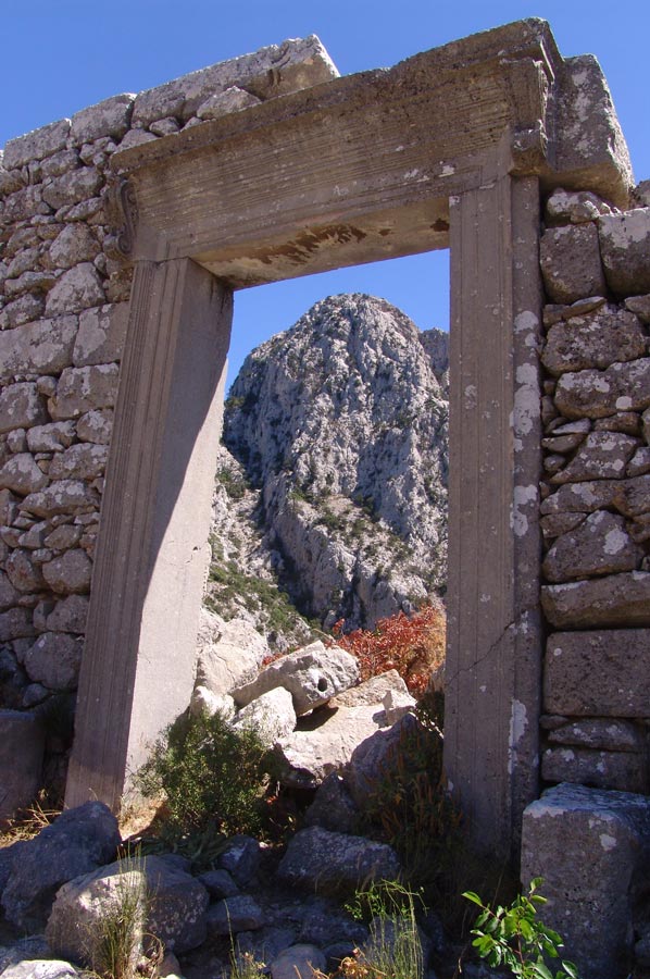
 Starting from Çamyuva, we soon walk through a lonely bay. The path continues to wind along the edge of the cliffs until the first sarcophagi and ancient ruins of Phaselis appear in the romantic pine forest. Legend has it that Laicos of Rhodes, the founder of this city, let the shepherd Sytabras choose between grain and fish as payment for his land.
Whatever he decided, at the end of the tour we can enjoy both culinary delights. Continue through the former port road to the southwest bay, the "city with three ports". A short climb lets us take another look at the magnificent port complex before we reach the end point of the hike, a quiet and lonely bay in Tekirova. Ascent: approx. 150 meters in altitude. Descent: approx. 150 meters in altitude, distance: approx. 10 km (pure walking time: approx. 4-5 hours).
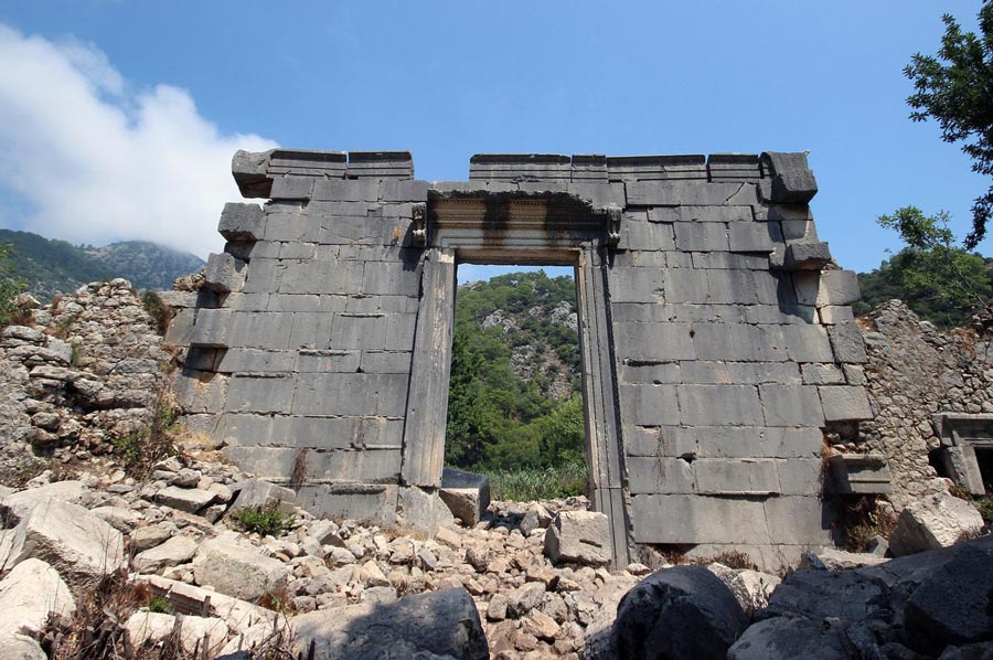
Tour 4: Termessos - The invincible city
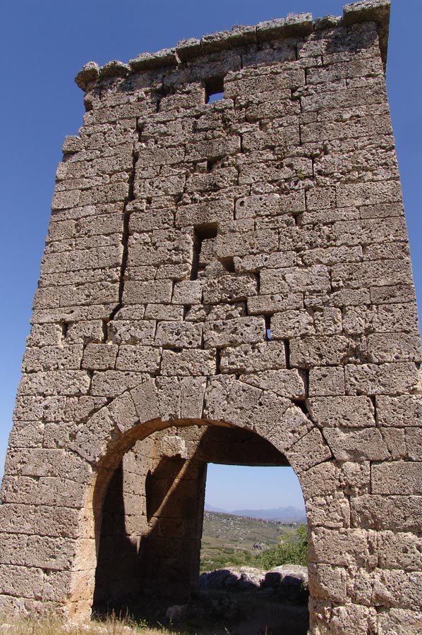 Termessos - why people retreated to this 1100 m high mountain 2000 years ago is something for scholars to explore.
The feeling of freedom that this warlike people might have felt, however, is unavoidably palpable in this impregnable rock city. The force of the earthquake that shook up the huge blocks of buildings and sarcophagi around 300 AD makes you shudder.
Nevertheless, you can imagine why not even Alexander the Great could conquer this rock nest. Climb approx. 250 meters.
Descent approx. 250 meters. Distance: approx. 12 km. (Walking time: approx. 4-5 hours).
Tour 5: A Yayla full of secrets
 The starting point of this hike is the small mountain village of Cedelme in the middle of the Tahtali Dagi mountains. The ascent follows an old shepherd's path through wonderfully fragrant pine and pine forests.
At the end of the path, a large yayla (summer pasture) with numerous fruit trees, old fig and pomegranate gardens unexpectedly spreads out before our feet. Wonderful view into the Göynük basin. The alpine huts with their old, artistically worked stones give us food for thought.
The short descent takes us through a cedar forest down into the valley of Altinyaka. At the final meal, we will once again experience Turkish hospitality up close.
Ascent: approx. 550 meters in altitude.
Descent: approx. 250 meters in altitude.
Length of path: approx. 12 km. (Pure walking time: approx. 4-5 hours).
Three stages on the Lycian Way
The most beautiful stages in the eastern part of the Lycian Way:
1. Çıralı - Yanartaş - Ulupınar
 Route: A varied hiking route over hiking trails, rivers and forest roads. This easy tour is highly recommended as an introductory hike for a hiking holiday around Cirali / Olympos....more
Duration: From the start at the Yanartas car park to Ulupinar, it takes about 2 hours. If you start the hike in Cirali at the restaurants, it takes about 3 hours.
Water: There is a small shop with cold drinks at the start, but there is also a tap with clean drinking water to fill up your water bottles.
2. Olympos - Musadağı - Adrasan
Route: The entire route is a clearly recognizable hiking trail. The start of this hike is in Olympos at the western end of the necropolis, near the large tomb.
Duration: For average hikers, 7-8 hours with breaks.
 Water: There is only one water source on the way, which you reach after 3 hours at the latest. It is advisable to take plenty of water with you, because the spring is not necessarily a safe bet, contrary to what some hiking books or helpful contemporaries claim. In summer, the spring only drips and there are no other water sources to be found until Adrasan.
3. Çıralı - Maden - Tekirova
Route: The route is a hiking trail up to the old mine in the “Maden” bay, after which the hike continues on an old forest road until it turns into a wide sandy track shortly before Tekirova.
Duration: For average hikers, 6-7 hours with breaks.
Water: There are no water sources, even if they are claimed in books and hiking maps!
Remaining stocks of the hiking guides with tour maps are available in English here: This email address is being protected from spambots. You need JavaScript enabled to view it.
The Lycian Way by Kate Clow
 Kate Clow and her trusty Billhook have spent years clearing the undergrowth of ancient Roman roads and mule tracks of pilgrims and miners, invaders and shepherds. She has stitched them together into a 300-mile walking trail between Antalya and Fethiye that alternates tantalisingly between high pastures and coastal villages, historic ruins and mountain peaks.
One of the BBC's unforgettable walks to take before you die!
What really sets this route apart is its close, almost cavalier, connection to history
Tim Salmon, Sunday Times
The famous British explorer Freya Stark wrote: "There aren't many places left where magic reigns uninterruptedly, and I know the Lycian coast to be the most magical of all."
Illustrated book with route map €20.00 postage and packing, order from This email address is being protected from spambots. You need JavaScript enabled to view it.
St Paul Trail by Kate Clow with Terry Richardson
 Turkey's second long-distance hiking route
Deep in the western Taurus Mountains on Turkey's Mediterranean coast, along ancient Roman roads and shepherds' paths, the spirits of St Paul and his followers live.
Paul came here to preach to Rome's most influential Asian "provinces". Today, the groundbreaking moment combines with the archaeology, history, religion and folklore of past and present civilisations on the sage-covered slopes and pine-clad hills of south-western Turkey.
Kate Clow, with the help of Terry Richardson and a volunteer team of intrepid hiking enthusiasts, has recreated the overgrown route St Paul took on his missionary journeys through Asia Minor.
Between Perge / Aspendos and Antioch lies a wealth of undiscovered, beautiful landscapes with gorges, waterfalls, cedar forests, limestone peaks almost 3,000 meters high and the glorious blue waters of Lake Egirdir, the fourth largest and most beautiful lake in Turkey. The trail winds through this dramatic landscape, connecting sections of Roman roads, medieval Seljuk and Ottoman trade routes, carriageways used by the semi-nomadic Yoruk people, footpaths in villages and forest tracks.
Illustrated book with route map €20.00 postage and packing, order from This email address is being protected from spambots. You need JavaScript enabled to view it.
The Kackar - Trekking in the Turkish Black Sea Mountains
 Kate Clow and Terry Richardson
The Pontic Alps (Kaçkar) have always been a wild refuge from powerful rulers, a refuge of individuality against conformity. As the glittering valley descends to the plain, the Kaçkar Mountains beyond raise their heads to the light and shadow of the sky.
Before the summer hay is cut, the meadows are bursting with spring flowers – anemones, poppies, bluebells and, in the lower plains, dusty white umbelliferous plants.
As the snow melts, the tiniest of treasures await the hiker – delicate crocuses or pink merendera, rich blue grape hyacinths and scilla, and the bells of fritillaria, deep brown on the outside but yellow on the inside.
This guide and map describe 32 routes in the Kaçkar Mountains, ranging from half-day hikes to multi-day treks. You can follow paved packhorse routes over passes between the granite towers or walk traditional footpaths between timeless villages and high pastures where hardy locals graze their herds.
Illustrated book with route map €20.00 plus postage and packaging, can be ordered from This email address is being protected from spambots. You need JavaScript enabled to view it.
Also available as a collection of all three books for €50.00 plus postage and packaging at: This email address is being protected from spambots. You need JavaScript enabled to view it.
Please read as well:
Kate Clow - Lycian Trail and others
Hike from Kahla up to Leuchtenburg (Seitenroda)
In hiking boots along the Albanian Alps near Nec
.