The idea came spontaneously in the morning when research on the internet made us aware that the Romans were also active on the Main during their campaign against the Marcomanni.
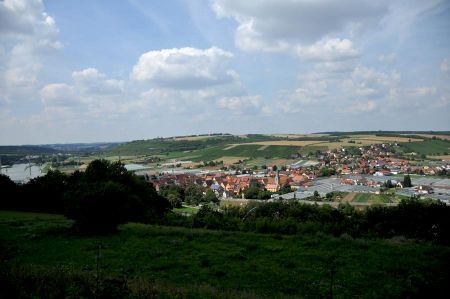
So the decision was quickly made to drive the few kilometers to the small town of Marktbreit, where an approximately 2.5-kilometer circular path along a former Roman camp invites you to take a walk. To get straight to the point, you should not expect excavations with remains of the Roman camp, because there are no ruins, at least visible. But it is an interesting circular route that has clear information boards about the Roman camp and offers a wonderful view of the Main valley as far as Kitzingen and Ochsenfurt. Here the relaxed walk along the path marked "Blue Butterfly" is in the foreground.
Base of operations for the camp in Marktbreit
 It was a small sensation when, in 1985, aerial archeology discovered the Roman camp on the Kapellenberg high above the tranquil town of Marktbreit, which dates back to Augustan times and was probably built between 5 BC and 5 BC. and 9 AD. Two precisely parallel ditches in the grain of a field had revealed the earlier existence of the Roman camp. Such an imposing Roman camp was not expected to be so far east of the Limes, because it was far in the "free" Germania and with its size of more than 37 hectares it was one of the largest camps of all. In terms of its outline, the aerial photos show that it resembles the legionary camp of Mainz am Rhein, about 140 kilometers away, which was probably also the base of operations for the camp in Marktbreit. The historians suspect that this Roman camp probably served to secure the Roman claim to conquered and pacified Germanic territory and at the same time also played an important role in preparing for the campaign against the Marcomanni. From the way the camp was set up, however, it can be concluded that this camp should not be used in the long term. There were only earth walls with wooden palisades for fortification, so it is assumed, since there were no significant conquests in the region, that the camp was not further fortified and later even completely abandoned.
The camp was secured by two pointed ditches
 Following the discoveries made by aerial archeology, magnetic prospecting was first carried out on the surface of the ground. Here, the measuring instrument is attached to a trolley, which can only be made of wood or plastic, which is then pulled over the area. The magnetic disturbances in the ground then show that there are structural changes in the ground.
The camp was secured by two V-shaped trenches and a wood-earth wall that was about 3 meters high and just as wide. Towers were placed at regular intervals to strengthen the defenses and to become aware of approaching enemies more quickly. The locations of the south gate and the north-east gate could be found out of the usual 4 gates of the camp.
Both gates were each about 20 meters wide and were specially fortified.
278 km from Mainz via the waterway to the Kapellenberg
The outbuildings of the legionary camp have been located near the southwestern flank. The core area of the multi-storey building had a rectangular area 25 m long and 21 m wide. Supporting pillars, which were founded up to 1.70 m deep, were intended to stabilize the upper wooden or half-timbered floors of the building. The overall system of the farm building comprised five rooms on the ground floor. Four of these rooms had a wooden floor. Planks were laid in parallel on sill beams, which were on the floor. The fifth room, which adjoined the other rooms in the form of a corridor at an angle, was partly furnished with air-dried clay bricks, and in the area of the kiln in the northern wing with limestone. The kiln was probably used to dry grain.
An architectural feature is a praetorium (commander's apartment) that is axially related to the principia (staff building) and connected to it. Such a central staff building can be found in the Roman camp in Haltern. Like the irregular floor plan and the design of the gate areas, this detail secures the dating to the Augustan period, six coins and a Terra Sigillata stamp more precisely to the years 5 to 9 AD become.
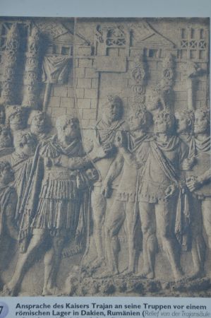
Submission of Gaul to Caesar
The find of the legionary camp on the Kapellenberg near Marktbreit proves an early Roman presence in Mainfranken. The discovery of the camp, far from Mainz, the base of the company, puts the Roman occupation in a new light. The camp was built between 5 B.C. and 9 AD, in an advanced phase of the Augustan Germanic wars. The concept of the procedure can only be guessed at based on findings and by evaluating traditional sources. It is therefore difficult to answer the crucial question of whether the occupation followed a long-term plan, whether camps that were created at the same time, such as Haltern an der Lippe, were part of a far-reaching movement towards the East, or whether there was only a reaction to challenges find. A possible goal of the Romans could have been the Elbe, in order to create a province of Germania and to draw the border as straight as possible to the tribes settling further east.
The Sugambri, the Usipeter-Trencterer, the Cherusci, the Suebi and the Chatti are known to have been opponents of the Roman Empire, which had extended to the Rhine line after the submission of Gaul under Caesar to the Rhine line for the period of the existence of the Marktbreiter base. The offensives to the right of the Rhine between the North Sea and the Alps could also have been directed against specific opponents in the interior of Germania, the directions followed the logic of the war. Whether the advance along the Main is a strategic parallel to the movement along the Lippe cannot be determined with certainty.
Core workforce to secure deployment and supplies
A historical situation can be well classified within this time horizon. The Marktbreit camp was probably set up in 5/6 AD during the Roman Marcomannic campaign, in which no fewer than twelve legions and their auxiliary troops took part. While the commander-in-chief Tiberius marched north from Carnuntum (Petronell-Carnuntum) against King Marbod, the legate Gaius Sentius Saturninus undertook an eastward thrust from Mogontiacum (Mainz), following the course of the Main, into Bohemia. Shortly before the unification of the two armies, however, the campaign had to be stopped because of the Pannonian uprising.
The Marktbreit camp fits exactly into this scenario, perhaps not so much as a transit camp with a small permanent workforce to ensure deployment and supplies during the campaign, but in view of the size and the representative buildings as a planned center after a large-scale conquest. This did not happen, which explains the extreme lack of finds. It is not yet clear whether the expansion was ever fully completed, but the large buildings certainly made an impression on the residents of the area. In any case, after the end of the campaign, the fortifications were burned down as no longer needed.
The seven clearly designed display boards along the hiking trail allow a deep insight into Roman history here on the Marktbreiter Kapellenberg, which is well supplemented by the exhibition of finds housed in the Malerwinkelhaus Museum as part of a permanent exhibition on the life and work of the legionnaires in the Roman camp. If you would like to deepen your knowledge of the Romans in this region, we also recommend a visit to the Franconian Open-Air Museum in Bad Windsheim. In the museum there there are numerous other sketches and models of the Roman camp near Marktbreit. We will also report on the Franconian open-air museum.
Please read as well:
Traces in the Vienna Woods - not just Romans and Celts
Volos - City tour through the harbor town of the Argonauts


