We were traveling in Amsterdam for a few days, completing all the tours by bike, but then crossed the canals through Amsterdam in an excursion boat despite heavy rain.
The canal network alone makes it clear how difficult the original settlement of today's province of Holland actually was: lots of moor, marsh and swamp, constantly changing water levels due to ebb and flow, plus floods from the North Sea or the rivers. Settlement was only possible through intensive hydraulic engineering and drainage of the land, which is why the Dutch are still considered the world's experts in dealing with water.
First steps in urban development by settling fishermen
 The land around modern Amsterdam was a very humid area that was intersected by several rivers, one of them called the Amstel, which ultimately flowed into the inlet called the IJ. Due to frequent and strong storm surges, the IJ had widened the mouth of the Amstel into a narrow, elongated bay. Around 500 fishermen had settled in huts on dams around this by the year 1230. The name of the later city of Amsterdam is derived from this dam with a lock in the Amstel River called Amstelredam, which was built in the 13th century, because the fishing settlement there slowly developed into a fishing village.
The dike built by settlers at the mouth of the river was necessary to protect the previously built buildings on both banks of the river from storm surges, because the Zuider Zee at that time was an open bay to the North Sea and the land was sinking due to drainage measures. The dam laid in the Amstel connected the settlement centres that had previously emerged on both sides, which are now referred to as Oude Zijde and Nieuwe Zijde (old and new side).
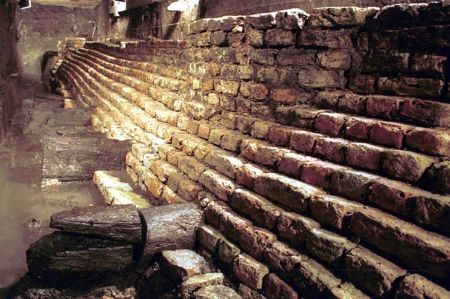
Foundation walls of the Kasteel van Amstel
 The lords of the Amstelland around the river of the same name were the noble family of van Amstel, who, as ministerial of the Utrecht Monastery, sat at the castle in Ouderkerk aan de Amstel until it was destroyed in 1204 by rebellious farmers from Kennemerland. They then built a new castle, the Kasteel van Amstel, the suspected foundations of which were found during excavations from 1994 to 1999 under today's Nieuwezijds Kolk street.
Florens V, Count of Holland, later tried to take control of the new trading port and granted its traders exemption from customs duties. Gijsbrecht van Amstel, who had rebelled against the Bishop of Utrecht, had to submit to the count as a vassal in 1285, but was involved in his murder in 1296. His son Jan van Amstel took advantage of a Flemish invasion of Holland in 1303 to break away from it, but was subdued after the Flemish left and had to raze the city walls and destroy the bridges; the place lost all trading privileges. These were only renewed after Amsterdam was finally incorporated into the County of Holland in 1317.
Around 1270 they had the river separated by the dam that gave it its name at the point where it widened into a bay. The settlement was first mentioned in 1275 as “Amstelledamme”. From this dam, the dike curved northwards on both sides of the bay, where today's streets Nieuwendijk and Warmoesstraat (and further south-east the Zeedijk) still run higher than their surroundings. Such dikes were also built elsewhere along the Zuiderzee. According to archaeological excavations, the old children's song Amsterdam, the beautiful city is built on piles, turns out to be quite correct: in fact, houses and streets could only be built with the help of countless piles as a base - rammed up to 18 meters deep through the marshy ground into the solid sand be built in swampland. The first church to be built in the second half of the 13th century was the Oude Kerk, replacing a wooden chapel. From 1408 the larger Nieuwe Kerk followed.
During the Middle Ages, an urban square was created on the site of the Amstel Dam, which still bears the name Dam today and is the centre of today's city.
Change in retail – from herring to beer
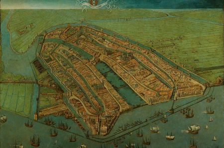
Fishing, initially the most important source of income, gradually gave way to trade, especially with dried or cured herring from the Swedish south coast and with beer from Hamburg, for which Amsterdam received an import monopoly in 1323. In 1347 locks were first mentioned, which made the laborious transport of goods over the dam unnecessary by allowing ships to pass through with their masts down. Later, locks were added at the entrance of the Amstel into the city and at its mouth into the IJ, and canals ran through and surrounded the city, as in the depiction by Cornelis Anthonisz. from 1538 can be seen.
At that time the city had around 30,000 inhabitants and consisted of the core of today's old town. Amsterdam was never a member of the Hanseatic League, with which there were trade conflicts and a dispute over passage through the Öresund, which was settled by compromise in 1441. New techniques (immediate gutting of fish while still on board) also made fishing in the North Sea more efficient. Salt and tropical fruits were imported from the Mediterranean. Amsterdam became a stacking and transshipment market and the goods were further processed, giving rise to production techniques, sciences, banking and insurance and printing.
Amsterdam was then also granted city rights, as Dordrecht, Haarlem, Delft and Leiden had previously received. Under the Counts of Avesnes and their successors, the Wittelsbachs of the Bavaria-Straubing line, Holland experienced a period of prosperity that ended with the invasion of Burgundian power - in 1433 Holland fell to Philip the Good, who ruled it from Brussels. The Hook and Cod War between 1350 and 1490 was a long-simmering power struggle between the bourgeoisie in the Dutch cities, in alliance with the Burgundian dukes, against the interests of the local feudal nobility.
Please read as well:
Visit to the Anne Frank House in Amsterdam
World famous old bridge "Stari most" crossing Neretva river

