Bicycle tour to Kallmünz - Pielenhofen an der Naab
- Written by Portal Editor
As already announced, there were to be further discussions on the German-Turkish Literature and Encounter Festival in Regensburg, which also included the presentation of our project vehicle.
After short research and a few contacts on site, we decided to drive to the campsite in Pielenhofen an der Naab. In addition to the immediate proximity to Regensburg, which can be easily reached by bike along the Naab and later the Danube, it was also the Naab itself and its immediate surroundings with its historic towns and castles that strengthened our decision.
Turned out to be an idyllic spot right on the banks of the Naab
 We arrived at the Pielenhofen campsite early in the afternoon, which, despite its considerable size and frequency, turned out to be an idyllic spot right on the banks of the Naab. As soon as we arrived, we were able to see children happily bathing in the Naab, canoeists and anglers passing by along the riverside path.
When the bikes were ready for use a little later and a first short trip around the campsite and into the village of Pielenhofen had been completed, our first impressions were confirmed: despite frequently changing guests who stopped off here on their way south due to the proximity to the motorway, peace and security, very helpful and competent staff, in short, nothing was missing to enjoy our stay alongside work.
We had received a map from reception
 Routine in handling the mover attached to the caravan made it easy to move the vehicle into the desired position, which is sometimes difficult to manage with human power alone due to the sloping terrain. So, the place was quickly set up, the satellite antenna aligned with the Internet access so that the daily mail could be dealt with and the first contacts were made with the neighbours, who of course were interested in the background of the project due to the Roman road maps on the caravan.
The very next morning we set off on our bikes towards Kallmütz, always following the course of the Naab and far away from the main road.
Thankfully, we had received a map from reception on which the 17-kilometer route was marked.
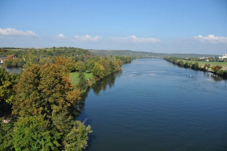
 So, we first reached Pielenhofen, then Kleinduggendorf, Grain am Berg and finally Kallmünz, whose name alone indicates a coin minting site. The ride to Kallmünz was already a relaxed bike ride with various breaks for photos and to look at the wonderful fauna and flora along the Naab, a river system of various source rivers with a total length of 165 kilometres, whose water catchment area covers an impressive 5,225 square kilometres until all the water flows into the Danube.
On the way and later in Kallmünz, however, we noticed the flood marks on buildings and squares, which indicate the negative sides of this huge catchment area of the source rivers. Water levels of over 5 meters above the normal river water level were not uncommon, something that is of course not at all in the current river idyll. During lunch in Kallmünz, we were able to speak in detail with a river resident and one of the victims of the last flood.
Twenty-four hours' warning time is hardly enough
 Twenty-four hours' warning time is hardly enough to secure your belongings and make the building flood-proof when the water level is 5 meters. Due to its location between the two rivers Naab and Vils and the steeply rising castle hill, the centre of Kallmünz is almost regularly hit by heavy flooding.
The Naab is formed west of the Upper Palatinate Forest around nine kilometres south of Weiden from the union of the right Haidenaab and left Waldnaab. It then runs south along the A 93 and the B 15, later the B 8, via Schwandorf and Burglengenfeld, among other places. It flows into the Danube from the left near Regensburg-Mariaort, just below the Black Laber, and forms a typical river valley with corresponding flora and fauna along its course.
- Haidenaab: The right or western source river rises in the Fichtel Mountains.
- Waldnaab: The left or eastern and longest source river rises in the Upper Palatinate Forest.
- Fichtelnaab: A right or western tributary of the Waldnaab rises in the Fichtel Mountains.
- Schweinnaab: A right or western tributary of the Waldnaab. Source around ten kilometers northwest of Parkstein. Flows into the Waldnaab in Weiden.
- Dürrschweinnaab: The smallest Naab. A right or western tributary of the Sauerbach, into which it flows near Altenstadt-Haidmühle. This is a left tributary of the Schweinnaab.
Stone Bridge, which was built between 1549 and 1558
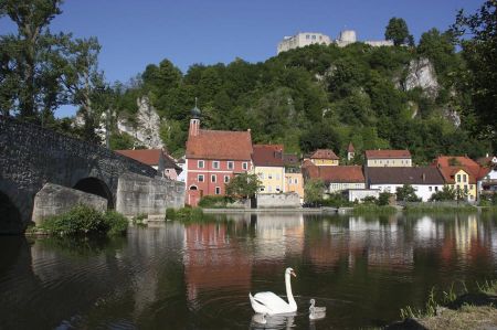
 We slowly approached the town of Kallmünz, which can be recognized from a great distance due to the castle ruins, the former Kallmünz Castle, which lie high above the town. We cycled into the town centre over the late medieval Stone Bridge, which was built between 1549 and 1558.
Unfortunately, parts of the stone bridge were damaged by ice in the 18th century and were even blown up by the Wehrmacht at the end of the World War in 1945, so that a modern reconstruction had to take place, which only slightly disturbs the character of the picturesque town. Old houses with a new look, some of which are crowded closely under overhanging rocks, give the town a medieval ambience, which reaches its most famous climax in the house without a roof right in the town centre.
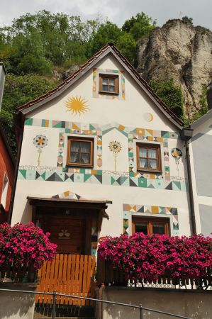
 Here a cave was converted into a house, the entire cave entrance was provided with a wall and associated doors and windows, giving the impression of a cave house similar to the stone houses in Cappadocia.
Perhaps it was this building or the entire local ensemble that repeatedly attracted artists to Kallmünz. The painter and professor Charles Johann Palmié, who once travelled from Munich, chose a newly opened inn in Kallmünz as his summer residence in 1901.
He himself gave the inn the name "Zur Roten Amsel" and illustrated its exterior facade al fresco with his Munich friends. The painters Wassily Kandinsky and Gabriele Münter became a couple here during their summer vacation in 1903. Kandinsky then developed a new style of painting with which he turned away from representational painting and towards the abstract art of "colour tones" (as he put it).
Expressionist painter Josef Georg Miller lived in Kallmünz
 Kallmünz soon became a scenically inspiring attraction for painters, who came here in ever-increasing numbers and some even settled permanently. The artists' colony soon had 38 painters.
It is less well known that famous Berlin painters also visited Kallmünz. Franz Skarbina, a friend of Palmie, was there in 1901, is one example. Magnus Zeller, a student of Lovis Corinth, visited Kallmünz several times during the Third Reich. Karl Schmidt Rottluff, the most famous of the Berlin painters today, was in Kallmünz in the autumn of 1936.
The important late expressionist painter Josef Georg Miller lived in Kallmünz from 1944 until his death in a traffic accident. In 1944 he and his wife Erna took over a pottery. After the Second World War, the artists ran a children's home.
 From 1979, the painter Hans Geistreiter lived and worked in Kallmünz until shortly before his death. From autumn 1984 he had his own studio for large works. Today there are numerous galleries that show the works of local artists as well as those of visiting artists. So you can easily speak of an artists' village.
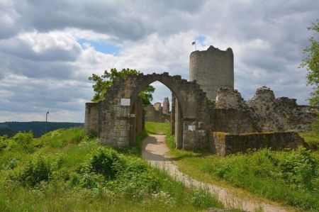
After our tour of the town, we set off for Kallmünz Castle, which stands high on the mountain spur, the so-called Schlossberg, at around 433 metres above sea level.
Right next to the church, a steep path leads directly up to the castle ruins. As the steps on this path are very high, the alternative path at the end of the town is better for children or older visitors, which is longer in loops but much more comfortable.
After the climb, you reach the gap in the castle wall and enter the extensive areas of the complex. If you have chosen the alternative route, you can go directly through the large castle gate into the inner courtyard.
Dates from the Middle Bronze Age around 1600 BC
 The first buildings on the castle hill were already in Celtic times, as excavations have shown. Even much older structures from the Bronze Age (around 2000 - 1900 BC) have been found here at the confluence of the Naab and Vils.
About 1000 meters in front of the Spornspitze, a two-phase outer section wall runs over the Hirmesberg, which dates from the Middle Bronze Age around 1600 BC, and, about 100 meters in front of the medieval castle complex, there was an inner section wall, also with multiple phases, from the La Tène period around 500 BC, which was later built over by the "Hungarian Wall".
This protective wall, still popularly known as the "Hungarian Wall" today, was probably intended to serve as a retreat for the local population during the Hungarian invasions in the 10th century.
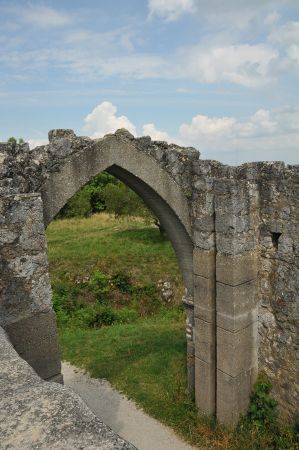 The castle, which is strategically located between the Naab Valley and the Vilstal at the intersection of several old roads and whose builders are not entirely clear, secured an imperial customs office that was already described as "old" around 1230. However, it was first mentioned in a document by Bishop Wolfgang in 983. The dates of the older high medieval castle buildings vary from 1150 to 1280.
The main castle was located at the very end of the foothills, directly above the steep drop to the Naab and Vils. The Romanesque architectural decoration of the polygonal two-storey palace with coupled round-arch windows, three-part pointed arch windows, two knights' halls and a castle chapel attached to the north, as well as the round 20-metre-high keep with a high entrance at a height of 8 metres, a diameter of 9.5 metres and a wall thickness of around 2.3 metres made of limestone ashlar masonry indicate that it was built between 1170 and 1780.
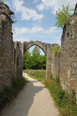 Later additions and remodelling indicate that it was built in the Gothic period. In 1271, a Bavarian ministerial named Hugo von Kallmünz was documented and in the House Contract of Pavia, the castle was first mentioned as belonging to the Wittelsbachs in 1329. Construction work that Count Palatine Rupert I had carried out in 1351 probably related to the 1.2-metre-thick ring wall with its semi-circular towers. The late Gothic moat with gatehouse is dated to the 15th century. During the Landshut War of Succession, Palatinate troops set fire to the castle in 1504. After its reconstruction during the Thirty Years' War in 1633, it was first plundered by imperial troops, then finally destroyed by fire by Swedish troops in 1641 and then served as a quarry. In 1793, the castle became municipal property and has been renovated several times since the end of the 19th century.
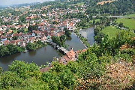
There were many other interesting details in the castle complex, which would go beyond the scope of this article. However, anyone interested should note that the walk up to the castle complex is definitely worth it, especially since the view of the town of Kallmünz and the confluence of the Naab and Vils with the colours of the surrounding forests is really impressive. Colours and shadow situations change depending on the position of the clouds and the sun, even the reflections on the water are impressive.
We were quickly back at the Pielenhofen campsite
 We stayed for a while on a bench directly above the town, which offered this wonderful view.
For the descent we used the alternative route described above, so that we quickly got back to our bikes.
The return journey along the Naab was no longer interrupted by frequent photography, so that we were quickly back at the Pielenhofen campsite.
A worthwhile day trip by bike, which can be extended if desired. Recommended.
Unforgettable bike tour to Kallmünz – Camping adventure on the Naab River - more details
Why take a bike tour to Kallmünz?
 Sometimes all you need is two wheels to find your true happiness.
The bike tour to Kallmünz combines exercise, nature, and history – all with the soothing sound of the Naab River in your ears.
You'll quickly realize: This route is more than just a way from A to B – it's a journey to yourself.
Who should take this tour?
Whether you're physically fit or more of a leisurely traveller – this tour adapts to you. Thanks to modern e-bikes, every climb becomes easy even for less fit cyclists. Perfect for couples, friends, or even families with older children.
Starting point of the trip – Planning and preparation
Equipment for a multi-day bike tour
Good preparation is half the battle. Before you start pedalling, you should carefully put together your gear.
E-bike or classic bike?
 An e-bike can make your life easier, especially if you want to relax and enjoy the scenery every now and then. For more athletic cyclists, a trekking bike with good gears is the perfect choice.
Key Packing List
- Tent, sleeping pad & sleeping bag
• Power bank & smartphone mount for the bike
• Repair kit & spare tube
• Light clothing (layered)
• Snacks & water bottles
• Flashlight & camping stove
Plan your route – navigation made easy
Apps like Komoot or Outdooractive will help you find the best routes. Don't forget: offline maps are worth their weight in gold if you don't have reception.
The route at a glance
From Regensburg to Kallmünz – A nature experience
The route usually starts in Regensburg. From there, the route winds along the Naab River through green valleys, past quiet villages and bizarre cliffs.
Highlights along the way
Picturesque landscapes
 Nature presents itself at its best here: meadows, forests, rock formations, and, again and again, the shimmering waters of the Naab.
Historical Sites and Buildings
Small chapels, old farms, and medieval bridges make the tour a true journey through time.
Kallmünz – A Jewel on the Naab River
What is there to discover in Kallmünz?
Kallmünz is an idyllic artists' village with charm. Cobblestone streets, small studios and galleries, and an imposing castle ruin characterize the landscape.
Kallmünz Castle
A must-see for every visitor. The climb is worth it: from the top, you'll enjoy a spectacular view over the Naab Valley.
Artists' Village with Flair
Many painters and creative minds have found their home here. Be inspired by the colours, shapes, and stories.
Culinary Stops and Regional Specialties
 Hearty snacks, freshly tapped beer, and homemade cakes – here, you eat with heart and soul.
Camping in Pielenhofen – Pure Nature
The Perfect Place to Relax
The Pielenhofen campsite is idyllically located directly on the Naab River. Ideal for unwinding after an active day in the saddle.
Local Activities – More Than Just Camping
Canoeing, fishing, hiking, or simply lying by the river and reading – here you'll find your perfect way to slow down.
Tips for Sustainable Travel
Environmentally Friendly Travel
Use reusable water bottles, garbage bags, and pay attention to regional products – for the sake of nature.
Support Regional Products
Buy your breakfast at the local bakery, enjoy local specialties, and support small shops. This way, the region's charm is preserved.
Conclusion – Why You Shouldn't Miss This Tour
The bike tour to Kallmünz and camping in Pielenhofen are more than just a vacation – they're an adventure that's good for body, mind, and soul. You'll experience nature, culture, and relaxation in their purest form. So, what are you waiting for? Hop on your bike and get ready for the experience!
FAQs about the bike tour to Kallmünz
 1. How long does the bike tour from Regensburg to Kallmünz take?
Depending on your pace and breaks, the route will take approximately 3–5 hours.
2. Is the route suitable for beginners?
Yes, it's easily doable, especially with an e-bike.
3. Can I park my bike safely in Kallmünz?
Yes, there are bike racks and often lockable parking spaces at guesthouses or restaurants.
4. Is a reservation necessary for the campsite in Pielenhofen?
Advance reservations are recommended, especially during peak season.
5. Are there places to stop for refreshments along the route?
Definitely! Numerous inns and beer gardens invite you to linger.
Please also read:
